|
|
|
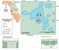
Lake
Johnson
|
|
|
|
Subsurface
Characterization
|
|
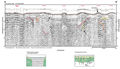
Acoustic
data from Lake Johnson is generally poor due in part to
a strong lake bottom multiple, signal attenuation and
technical difficulties. Parallel, horizontal reflections
are present above 12 ms (8.7 m below lake surface) that
may represent in situ and transported Plio-Pleistocene
sands (Type 6, A-A’).
Below 12 ms, only “windows” of interpretable
data are present. Sections of the data can be resolved
to approximately 32 ms (10 m). High angle reflections
suggest collapse of material into a large sink (Type 1,
A-A’) and
smaller, concave reflections that suggest subsidence into
smaller sinks or dissolution pipes (Type 4, A-A’).
|
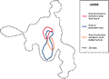
Lake
Johnson appears to have formed by the coalescing of many
collapse sinkholes. After the initial collapse of an individual
sinkhole, the sides have eroded into the central portion of the
sink, flattening the banks and filling the center. A very
steep-sided, deep sink is located near the entrance of
the adjacent Gold Head Branch State Park and may represent
the younger stages of this process. The area where the seismic profiles were run is relatively flat bottomed
and shallow, indicating a more mature feature. Flow into
Lake Johnson with no outflow indicates direct recharge
to the aquifer.
|
|
|
|