|
|
|
Sand
Hill Lake (Lake Lowry)
|
|
|
|
Introduction
|
|
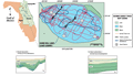
Sand
Hill Lake (also known as Lake Lowry), located in Clay
County (approximate latitude 29°50’22”N
and longitude 81°0’12”), is a semicircular
lake (about 2 by 3 km) with a 32.5 km perimeter and area
of 7.6 km2 (Track
Map). This lake, unlike Kingsley
Lake, has buried and implied active subsidence features
(Type 2). Like many of the lakes formed by sinkholes,
Lake Lowery has a relatively shallow bottom (2-5 m) from
the shore toward the center of the lake and a central
part eight to ten meters deep.
|
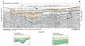
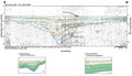
Similar
to Lakes Magnolia
and Kingsley, Lowry
is flanked on the west by the Trail Ridge deposits. The
lake is underlain and surrounded by Citronella
sediments (Clark, 1964),
which consist of a relatively thick section of unconsolidated
to semi-consolidated quartz sands, clayey sands, and gravels.
The sediments are unconsolidated and completely saturated,
this enhances the filling process when sinkholes collapse
or sediment is washed into the lakes by surface runoff.
Generally the sands are seismically transparent but clay
stringers or cementation may provide reflecting horizons.
|
|
|
|