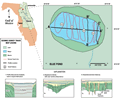
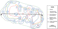
Blue
Pond is located in western Clay County. The lake borders
on the Volusia
Ridge Sets of the Eastern Flatwood District and the
Interlachen Sand
Hills of the Central Lakes District. Lake level at
the time of the seismic survey was about 40 m (130 ft)
NGVD. Blue Pond is oval shaped, approximately 750 x 350
m with a perimeter of 4.6 km and a surface area of 1.3
km2. Average water depth
during the survey was about 9 m (30 ft). Blue Pond is
connected surficially to Sand
Hill Lake to the south.