|
|
|
Lake
Johnson
|
|
|
|
Introduction
|
|
The
unique physiography of the region can be seen in the hillshade
view presented on Index
Map A. The landscape is dotted with lakes that are
incised into the surrounding sand hills. Large, flat bottom
prairies, such as Levys Prairie in the southwest section
of the Interlachen Sand Hills, attest to the erosional
process of internal drainage into sinkholes. There is
only a poorly developed surface water drainage system
in the sand hills. A well developed drainage can be seen
in the northeast section of Index
Map A in the Penny Farms Uplands. This is related
to the thicker section of Hawthorn Group and the lack
of sinkhole development.
|
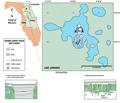
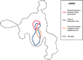
The
irregular shape of Lake Johnson gives it a perimeter of
over 10 km, with an area of only 2 km2.
Lake level at the time of the survey was 29 m (95 ft)
NGVD. Gold Head Branch flows into Lake Johnson from the
northwest and there is no surface water outflow points.
|
|
|
|