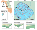
Lake
Magnolia is on the southwest boundary of Clay County,
Florida and is located in the Interlachen
Sand Hills of the Central Lakes District. Lake level
at the time of the seismic survey was 38 m (125 ft) NGVD.
Lake Magnolia is oval shaped approximately 1.1 x 0.9 km
with a perimeter of 3.2 km and surface area 0.8 km2.
Average water depth during the survey was 6 to 7 m (19
to 23 ft). The lake is bordered by woodlands. Lake Magnolia
is flanked on the west by the Trail Ridge deposits with
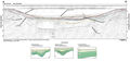
Citronella deposits elsewhere. The lake is underlain by
Citronella sediments (Clark,
1964) which consist of a relatively thick section
of unconsolidated to semi-consolidated quartz sands, clayey
sands, and gravels. The Trail Ridge sands are above an
elevation of 45 m (149 ft) and are mined commercially
for heavy minerals used in paints and abrasives. The sediments
are unconsolidated and completely saturated, this enhances
the filling process when sinkholes collapse or sediment
is washed into the lakes by surface runoff. Generally
the sands are seismically transparent but clay stringers
or cementation may provide reflecting horizons.