|
|
|
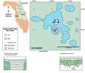
Lake
Johnson
|
|
|
|
Subsurface
Characterization
|
|
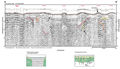
The
geologic units present at Lake Johnson are typical of
northeast Florida stratigraphy. The surface material consists
of Plio-Pleistocene sand hills. The lakes within these
hills define the surficial aquifer system of the region.
The natural gamma logs from two wells south of Lake Johnson (Index
Map A, wells C-0453
& C-0457) indicate
that these sands are present above +28.1 m (90 ft) NGVD on the western side below Lake Johnson and may be missing or only a few feet thick on the eastern
section of the lake.
|
Below
the sands, the clay and sandy clay of the Hawthorn Formation
can be identified in the gamma logs by the sequence of high peaks between +28.1 m (90 ft) and -21.8 m (-70
ft) NGVD in well C-0453.
Most of the imagable area of the seismic profiles is within the Hawthorn Formation. Below -21.8 m (-70 ft),
the Eocene carbonates of the Ocala Limestone are identified
by the extremely low counts (less than 20 counts per second)
on the natural gamma logs. These depths are below the
imagable areas of the seismic profiles.
|
|
|
|