|
|
|
Kingsley
Lake
|
|
|
|
Introduction
|
|
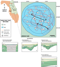
Kingsley
Lake is a circular lake centered at approximately latitude
29°57’54”N and longitude 82°W in west-central
Clay County, Florida. The lake is located within the Trail
Ridge area of Sea Island District. Kingsley Lake is
flanked on the west by the Trail Ridge deposits and is
underlain and surrounded by Citronelle sediments (Clark,
1964) that consist of a relatively thick section of
unconsolidated to semi-consolidated quartz sands, clayey
sands, and gravels. The Trail Ridge sands are above an
elevation of 45 m (149 ft) and are mined commercially
for heavy minerals used in paints and abrasives. These
sediments are unconsolidated and completely saturated,
this enhances the filling process when sinkholes collapse
or sediment is washed into the lakes by surface runoff.
Generally the sands are seismically transparent but clay
stringers or cementation may provide reflecting horizons.
|
Lake
level at the time of the seismic survey was 54 m (176
ft) NGVD. This circular lake is approximately 3.2 km in
diameter with a perimeter of 12.8 km and surface area of 5.6 km2.
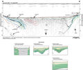
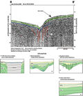
The deepest part (40 ms, ~30 m) of the lake southeast
is of the center where a large, steep-sided, collapse sinkhole is located. Otherwise,
the lake is shallow around the shoreline, gradually deepening
to 6 m (Track Map).
Towards the center of the lake the bottom slope steepens
and increases in depth from 6 to 15 m (Track
Map).
|
|
|
|