|
|
|
Lake
Johnson
|
|
|
|
Introduction
|
|
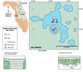
Lake
Johnson lies within the Central Lake District physiographic
province. It is within the Interlachen
Sand Hills subdistrict. The lake is adjacent to the
Trail Ridge Sands which is a paleodune ridge that extends
north into Georgia. This region includes the largest number
of cover collapse sinkholes and provides direct recharge
to the underlying Floridan aquifer system. Vegetation
that includes longleaf pine and turkey oak is prevalent.
Internal drainage through the sinkhole lakes has limited
the formation of streams except during periods of high
rainfall.
|
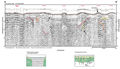
The
surficial sands provide storage for rainfall and recharge to the lakes during high water-table conditions.
The potentiometric surface of the Floridan aquifer is
lower than the lake so a continual downward gradient exists and provides the mechanism for recharge. Pathways for recharge exist where the thick clay and sandy clay units within the Hawthorn Group are breached by collapse sinkholes.
|
|
|
|