|
|
|
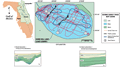
Sand
Hill Lake (Lake Lowry)
|
|
|
|
Subsurface
Characterization
|
|
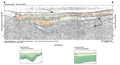
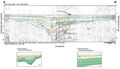
Sinkhole
lakes can be delineated into a progressive
sequence of lake formation based on geomorphic types (Sinkhole
Evolution). The progression begins with the initial
collapse, forming a sinkhole. The depression may be open
or, if a portion of the depression is below the water
table, it may be filled with water. As sediments are washed
into the depression, the sinkhole becomes plugged. The
process continues until the sinkhole is buried.
|
Lake
Lowry is in the transitional phase (middle age), when
the lake becomes partially or completely plugged, the
lake begins to develop a shallower and flatter bottom.
During this phase the plug may be flushed into the karst
(faults, fractures, and/or solution pipes), allowing the
sinkhole to reactivate and revert to an active subsidence
phase, described above as subsidence activity and hiatus
with slow sediment depostion (A-A’
and B-B’).
This may occur several times until sediment accumulates
faster than dissolution of the underlying limestone.
|
|
|
|