|
|
|
Lake
Magnolia
|
|
|
|
Subsurface
Characterization
|
|
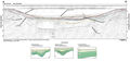
Profile
A-A’ shows
the basic character of Lake Magnolia, which appears to be comprised of a single depression.
The characteristics of this lake are very similar to Kingsley
Lake, Blue Pond and several other lakes in the region. The
subbottom was disturbed during the subsidence then covered
and infilled similar to Types 2 and 6 karst features described on the Karst Features
pages. In the northwestern corner of the lake is a buried block that has rotated and slumped
into the sink (Type 3).
|
The
main depression is continuous across the lake in both
of the predominant traverse directions. Profile A-A’
from Lake Magnolia shows a singular subsidence that is
shallow nearshore with onlapping fill on the northwest
flank. The central portion of the lake has an undisturbed
surficial layer that is acoustically transparent and is
possibly composed of high-organic sediments termed “gyttja”.
The undisturbed nature of the surficial sediments implies
that there has been little to no recent subsidence. In
this case, as the sink became plugged, the lake developed
a shallower and flatter bottom due to the infilling associated
with runoff and eolian processes.
|
Correlation
of gamma logs from the boreholes to contacts seen in the
seismic records is tenuous. Log C-0451
is from a well approximately 1 km west of Lake Magnolia
and log C-0439 is
from a well located on the northwest shore of Sand
Hill Lake (Index Map
A). The units identified from the gamma logs are the
clay confining units of the Hawthorn Group and the top of
the Ocala Limestone. The blue horizon in profile A-A’
has been interpreted as a reflection near the top of the
Hawthorn Group.
|
|
|
|