|
|
Identification
of Karst Features from
Seismic
Profiles
|
|
Historically,
high-resolution single-channel seismic profiling
(HRSP) has been used to determine the regional distribution
of stratigraphic units having distinct acoustical characteristics.
In this study, the lakes are well distributed and have
a relatively small diameter, making stratigraphic correlation
difficult. HRSP data has been used primarily here to map
the shallow subsurface features found beneath selected
lakes of northeastern Florida. Subsurface diagnostic features
are used to define the structural history and to locate
possible breaches in the confining layer that maintains
the perched lakes above the Floridan aquifer. In many
cases the acoustical records show fine details of karst
(>10 m) and karren (<10 m) features (Ford
and Williams, 1992). Compilation of these features
from seismic profiles acquired from the lake surveys have
shown that certain acoustic patterns reoccur from lake
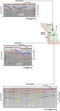
to lake. Figure
14 shows similar acoustic patterns from three lakes
located in separate geomorphologic regions. In general,
low angle, parallel reflections are down warped to form
a depression. These reflections are accompanied by discontinuous
or segmented reflections that suggest structural displacement
and subsurface subsidence. Horizontal reflections overlying
the subsidence indicate subsequent fill.
|
The
reoccurrence of these features in seismic sections from
the more than 39 sites profiled (Fig.
1, Introduction)
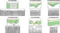
led to the identification of six
acoustical signatures of commonly found karst or geologic
features. These features are characterized in Figure
16. Included in the summary are patterns indicative
of no acoustic return (Fig.
16 type 1). Negligible or noisy acoustic return unfortunately
is common in the lake surveys and are typically the result
of various environmental and geomorphologic factors. Such
factors include organic material collecting in depressions
that disperse the acoustic signal, or a lithologically
“hard” lake bottom of packed homogeneous sands.
A karst surface near the lake bottom may also disperse
the signal or cause ringing (multiples) throughout the
record. Side-wall reflections from the shoreline or slope
of a depression may further obscure return from subsurface
features. Acquisitional deficiencies such as electrical
noise or faulty grounding may affect entire surveys, as
do lake surface wind, chop or waves.
|
When
the record is not obscured, a number of patterns have
been identified that relate to karst features. Types 2
and 3 (Fig. 16)
represent depressions that have been subsequently filled
to the present lake bottom. The fill is represented by
horizontal reflections that may onlap the depression or
completely cover the subsided area. Evidence of stress
fractures, slumping, faulting, or dissolution fractures
around the depression (type
3) differentiate the two dolines and may indicate
more rapid or continuous subsidence, or a more competent
overburden. These breaches within the depression may provide
a significant hydraulic connection between surface waters
and the underlying aquifer. Most of the sinkholes detected
using HRSP are of the buried base-level type (Fig.
13, Sinkhole
Evolution) and should be a common occurrence beneath
dry land as well. Only when these features develop a transitional
phase (Fig. 13),
reactivate and cause a surface subsidence or collapse,
do they become evident at the surface.
|
|
|
|