|
|
|
Kingsley
Lake
|
|
|
|
Subsurface
Characterization
|
|
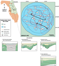
Profile
A-A’ illustrates
the strata in and around the primary sinkhole within the
lake. An abrupt change in the lake bottom slope can be
seen on the flanks of the sinkhole. This is a filled,
collapse-sinkhole with steep flanks overlain by offlapping
fill and slumps. The fill is acoustically transparent
with few low-amplitude reflections discernible. This is
to be expected since the source of the fill is primarily
clean quartz sands brought in from the adjacent Trail
Ridge deposits. Plotted on the Kingsley Lake survey track
map are the karst features identified from seismic profiles;
Types 1, 2, 3, and 6 karst features were found. Features
1 and 2 represent the primary sinkhole surrounded by Type
6 undisturbed depostional layers.
|
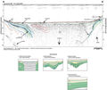
The
Type 1, 3 feature seen in profile B-B’
appears to be a secondary collapse feature that occurred
after the formation of the main doline shown in profile
A-A’. Unlike
the main doline, this feature is not completely filled
with sediment. The data does not indicate that the feature
extends through the surficial and Hawthorn Group sediments
into the Floridan aquifer (>95 m).
|
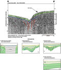
There
is only limited borehole data available to correlate the
seismic data. Interpolating from the nearest borehole C-0478
(Index Map A) the
top of the Hawthorn Group is seen along the shallow flanks
of the lake at approximately 10 ms. In profile A-A’
the top of the Hawthorn Group is shown to be steeply dipping
towards the center of Lake Kingsley due to the sinkhole
collapse. It is estimated that the top of the Floridan aquifer
should be seen in the data at approximately 150 ms. None
of the profiles contained data that was resolvable at that
depth however.
|
|
|
|