|
|
|
Orange
Lake
|
|
|
|
Southwest
Area
|
|
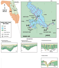
The
southwest area consists of a broad flat bottom with a
bathymetry very similar to that in the southeast and north areas, except for the collapse sinkhole (type 5, D-D’)
near the southwestern shore. The sinkhole has completely
breached the confining unit. It is possible that other
features are present but access was limited by aquatic
weeds and the southwest area could not be completely surveyed.
|
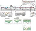
The
clustered collapse sinkholes are near the southwestern
shoreline adjacent to Heagy-Burry Park and boat ramp.
Observations by scuba divers indicate that there is a
downward flow of water from the lake into one of the sinks
(Spechler and Wilson,
1992). Reports by Pirkle
and Brooks (1959b) and Spechler
and Wilson (1992) indicate a direct hydraulic connection
with the aquifer. During the 1956 drought, water from
Orange Lake could be seen draining into the collapse sinkhole
of Heagy-Burry Park. Profile D-D’
shows the steep slope and fault blocks of the sinkhole.
The mass movement of limestone blocks would open pathways
for water to migrate along the fractures. Sediment slumping
along the steep flanks of the sinkhole also are visible
and are part of the natural process that plugs the doline.
Adjacent to the collapse are evidence of adjacent cover
subsidence sinkholes that ultimately may coalesce in the
sinkhole complex.
|
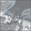
A
three-dimensional bathymetric
grid of the clustered sinkholes near Heagy-Burry Park
is shown below. The grid model was constructed using the
two-way travel time for the lake-bottom reflection (HRSP).
Two collapse sinkholes and two adjacent subsidence features
are evident from this model. It is not clear if the features
are remnants from the sinkhole that was observed in 1956
or are sinks that have formed since. Past reports (Rowland
1957, Jessen 1972)
indicate that a single hole approximately 63 m (20 ft) in
diameter was exposed. A temporary sandbag and earthen dam
emplaced around the hole subsequently collapsed into the
hole. Large quantity of fill, a storage tank, and junked
vehicles were also placed into the hole. Remnants of the
dam, and hence the most northern boundary of the 1956 sink,
can presently be seen about 10 m offshore from the park.
The satellite
overlay figure shows the contours of the sinkhole superimposed
on an enlarged aerial
photograph of the Heagy-Burry Park area. The photo and
overlay show the extent of the collapse and subsidence features,
including a sinkhole on land in the southeastern portion
of the photograph. An area east of the boat ramp is continually
subsiding and fill material is periodically emplaced in
the depression. Though the limits of the sinkhole observed
in 1956 are not known, it is clear that this area represents
a sinkhole complex that is still quite active and expanding.
|
|
|
|