|
|
|
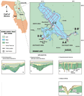
Orange
Lake
|
|
|
|
Southeast
Area
|
|
The
southeastern area of Orange Lake has a water depth of 1 to 3 m (3 to 9.8 ft). The primary karst features within
this area are cover subsidence sinkholes and associated fissures
(A-A’, B-B’).
These features have type 2 and 3 characteristics (Track
Map), where the overburden has subsided to accommodate
loss due to solution in the underlying limestone. Less
common karst features have also been identified, such
as buried sinkholes, faults and dissolution pipes.
|
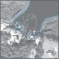
The
large subsidence along the southern shore measured approximately
400 m (1312 ft) in diameter (A-A’).
The surface expression is apparent on the lake bottom
as a slight subsidence. Horizon HL (A-A’,
type 2, HL) forms a depression filled by onlapping cover
sediments. Several high-angle faults are present, with
little vertical displacement. These features may also
represent dissolution pipes. Leakage of lake waters to
the aquifer in these and similar areas is controlled by
the permeability of the cover sediments or proximity of
the faults to the lake floor. Of the features identified
in the southeast area, very few appear to breach the lake
bottom.
|
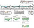
A
small number of depressions found in the southeastern
area may be linked to more active sinkhole development
(B-B’, type
3). The type 3 feature is smaller than the type 2 (~ 50m,
164 ft). The pattern of disturbed horizons implies active
subsidence with intervening periods of deposition. As
the sinkhole subsides, it is subsequently filled by sediment,
seen as onlapping reflections within the depressions,
followed by differential subsidence. Buried by <1 m (3.3
ft) of sediment, this sinkhole is an example of the composite
mature subsidence sinkhole. A proposed model for subsidence
sinkhole development is outlined in the figure below (B-B’
Diagram).
|
|
|
|