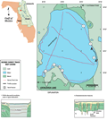
Lochloosa
Lake is located in the Alachua Prairies, southern Alachua
county. Part of the Ocala
Uplift, this area of highly mature karst terrain has
been dissolved virtually to the water table (Brooks,
1981), creating loosely connected marshlands and lakes.
Lochloosa is connected via Cross Creek to Lake
Orange, which ultimately connects via canal to Paynes
Prairie to the north. The shoreline is predominantly marshland,
with Lochloosa creek to the north and Little Lochloosa
and Right Arm Lochloosa Lake to the south and west. Lochloosa
Lake is irregular in shape, with a perimeter of 21 km
(13 mi) and an area of about 22 km2.
Lake elevation at the time of the seismic survey was 17.5
m (57.5 ft) NGVD.