|
|
|
|
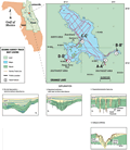
The
north and central areas of Orange Lake are geologically
similar and will be combined and discussed as one area.
The lake bottom and subsurface are relatively flat and
intact with small subsidence features throughout. The
unconsolidated surficial sediment is a sandy clay that,
along with the shallow water depth, produces strong multiple
reflections that mask much of the geologic data (type
1, C-C’).
The vertical features in the cross section may indicate
the early stages of a subsidence sinkhole, with the central
area actively subsiding and/or collapsing. The high angle
reflections throughout the profile may represent stress
fractures created by slumping as the overburden accommodates
dissolution at depth. The features may also represent
dissolution pipes through the overburden, indicating a
breach in the confining layer.
|
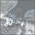
Features
in the northern portion of the lake are generally small
(1 to 10 m across, 3 to 33 ft) and tend to be isolated.
Distribution and size of features in this area are different
than the features in the southeast that tend to cluster
together to form larger (>100 m, 328 ft) structures. Surface
features and shallow horizons (< 2 m, 66 ft) were seen
in the HRSP data that indicated a number of subsidence
sinkholes in this area (type
3) and type 4
karst features that have clustered to form disturbed areas
in the subsurface, up to 40 m (131 ft) across. Most of
the area between Samsons Point and Boardman show some
form of subsidence.
|
|
|
|