|
|
|
|
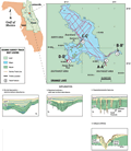
Orange
Lake is located in Alachua County, north-central Florida.
The lake occupies the physiographic division known as
the Alachua Prairies
(Brooks and Merritt,
1981). Advanced karst development in the subsurface
created solution valleys that are characterized by flat-floored
depressions with numerous dissolution features. A geologic
term for these environments is polje. These broad,
drowned prairies occupy the epiphreatic zone and are strongly
influenced by fluctuations in the water table. An extreme
example is Paynes Prairie to the north which commonly
fluctuates from grassland to marsh to completely inundated
and was at one time known as Alachua Lake.
|
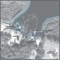
Orange
Lake is a relatively shallow, irregularly shaped lake
with approximately 44 km (144 ft) of shoreline covering
30 km2, with much of
the shore grading into freshwater marsh. The surficial
sediments of the lake bottom are organic and/or organics
mixed with sand and clay, transported into the lake by
storm runoff and streams (Rowland,
1957).
|
|
The
west side of the lake is flanked by the Fairfield Hills,
a Pleistocene sand ridge which may supply some of the sediments
to the lake bottom. The ridge overlies the less permeable,
Miocene sediments of the Hawthorn Group. In the southwestern
corner of the lake, the shallow bottom gives way to a cluster
of dolines (sinkhole complex) that penetrate the semi-confining
layer into the karst limestone beneath. Pirkle
and Brooks (1959a) suggest that the sands and clays
of the Hawthorn Group are typically impermeable. When the
water table drops, under sufficient hydrostatic pressure
from the surface water, this material will fail and be flushed
into solution channels in the limestone. Once the outlets
are opened, the lake water will adjust to the level of the
water table in the limestone unless the sinks again become
plugged.
|
|
|
|