|
|
|
Orange
Lake
|
|
|
|
Subsurface
Characterization
|
|
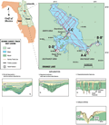
The
geologic structure of Orange Lake in general is a semi-confining
unit overlying limestone karst. The Plio-Pleistocene surficial
sediments include sands and clays that range in thickness
from ~1 m (~3 ft), over most of the area, to about 20
m (67 ft) in the Fairfield Hills. These sediments are
underlain by clays, sandy clays and carbonates of the
Miocene Hawthorn Group. Natural gamma logs from boreholes
adjacent to Orange Lake indicate that the clays range
in thickness from about 5 m south and southwest of the
lake, to more than 25 m (82 ft) on the east side. Horizon
HL in profile A-A’
below may represent the top of the Hawthorn Group. The
Ocala Limestone carbonates are the oldest units exposed
in this area and can be seen in roadcuts and numerous
quarries. The contact between units exhibits highly irregular
surfaces typical of karst. The top of the Ocala Limestone
range from about 6 m to > -6 m (20 to > -20 ft) NGVD,
with an overall trend dipping to the northeast. Dissolution
of the carbonate is active and can be seen at the Heagy-Burry
Park. For years, dirt fill has been periodically brought to
an actively subsiding sinkhole on the east side of the
park’s boat ramp and is representative of cover subsidence sinks in Orange
Lake. Land-based ground penetrating radar profiles from
the park adjacent to the collapse sinkhole indicate numerous
buried sinkholes and cavities (Davis,
1996).
|
Additional
work regarding Orange Lake not included in this summary can be found in Kindinger and others (1994, 1998).
|
|
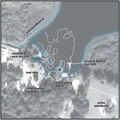
In
the following discussion Orange Lake is divided into three
areas (Track Map)
based on distinct geomorphic features identified from HRSP
profiles. The primary karst features found within the lake
are in various stages of maturity and include cover subsidence,
cover collapse and buried sinkholes.
|
|
|
|