|
|
|
Cowpen
Lake
|
|
|
|
Subsurface
Characterization
|
|
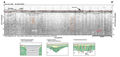
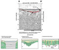
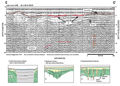
The
acoustic signal in Cowpen Lake as a whole is relatively
weak. This is shown in the example profiles (A-A’,
B-B’ and C-C’).
Factors which contribute to a noisy or weak acoustical return in the lakes of this
study area include proximity of hardbottom (limestone)
to the sediment surface, accumulation of organic debris on the lake bottom, shallow water depths
and proximity, steepness and irregularity of the shoreline.
In Cowpen Lake, the nearby and irregular shoreline could
create interference (noise) in the signal, and the marshy
area in which it resides could produce organic-rich surficial
sediments which dampen the return. As a result, little
can be seen in the seismic profiles at left about 10-12 m. The lake bottom shows an undulating
surface marked by localized subsidence less than tens of meters in width.
Accumulations of material is imaged near surface in the
bathymetric lows (red lines, profiles B-B’
and C-C’). This
could represent fill from the surrounding sand hills.
In the subsurface, high frequency reflections occasionally
can be seen (orange dashed lines, A-A’
and B-B’). These
may represent dissolution-type features or disturbed bedding and could indicate breaches in the
overburden. The contact between the top of the Hawthorn
Group and overlying undifferentiated fill is interpolated
to be around 12 m (39 ft) below lake level (Index
Map A). This contact is difficult to detect in the
seismic profile because of the signal noise and multiples,
but the disturbed bedding at depth would indicate breaches
in the confining Hawthorn Group. The top of the Ocala
Limestone is estimated to be around 20-30 m (67-98 ft)
below lake level (~0 ft NGVD), but is obscured in the
profiles. Solution of the limestone at depth could produce
dissolution type features which transport material downwards
and can create the smaller subsidence areas seen at the
surface.
|
|
|
|