|
|
|
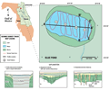
Blue
Pond
|
|
|
|
Geologic
Characterization
|
|
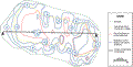
Blue
Pond appears to be a single large depression, (B-B’ and C-C’).
Many lakes surveyed in this area all appear to have this characteristic (i.e. single basin, single sink), whereas others occur as a complex of depressions. The steep sides of these lakes infer they are young and in
the active subsidence or collapse phase (Kindinger
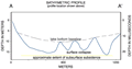
and others, 1998). At depth, a strong subsurface reflective
horizon at about 30 m below lake level (C-C’)
is interpreted to be the karst surface. However, interpretations
of gamma log profiles to the south put the top of the
Ocala Limestone
at nearly 60 meters below the lake surface. Johnson
(1986) a report that the top of the Marks Head Formation
at this depth in a well approximately 4.8 km (3 miles)
north of the lake. The Marks Head Formation is part of
the Hawthorn Group and is characterized as interbedded
dolomite, sand and clay. This horizon is collapsed throughout
most of the lake as shown in yellow in the bathymetry
map. The subsurface collapse has created general surface
subsidence, as well as slumping of the overburden into
the depression (B-B’).
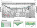
Smaller areas of surface collapse are evident at the lake
bottom (green line, C-C’). The smaller collapse structures may be
a result of accommodation during subsidence, or solution
features created by water movement. These surface breaches
probably provide pathways for aquifer recharge from the
surface waters. The areas of surface collapse have been
mapped in red in the contour plot (A-A’).
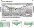
The profile at right with the contour plot (A-A’)
shows the relationship between the lake bottom, the surface
features and the subsurface collapse. Most of the profiles
from the survey are obscured by acoustic noise, which
masks returns from structure within the depression. The
noise and multiples appear to be related to the shape
of the seismic lake which produces ringing in the acoustic
return. This signature is relatively common (Type 1) and
can be compared with similar seismic returns seen in other
lakes in the study area.
|
|
|
|