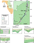
An
additional cross section comes from three wells drilled
on the small islands in the Wekiva River (E-E’,
Index Map E). Again,
the variability within the post-Tertiary units is apparent,
note the high peak in well S-0866
at 3 m (9 ft) NGVD. One mile north in well S-0864,
this peak is completely missing as are all of the other
clay rich beds in S-0866.
The log for S-0864
shows 17 m (55 ft) of clean material, probably sand, below
which is a clay unit that may correlate with the blue
line in profile B-B’
and represent the top of the Hawthorn Group. The gamma
peaks in well S-0866
show that the Hawthorn Group may extend to about -6 m
(-20 ft) to -8 m (-25 ft) NGVD. These logs probably do
not represent the total drilled depth of the wells since
they do not penetrate the Ocala Limestone, yet surface
flow and water quality are indicative of the Floridan
aquifer. Depth to the Ocala is inferred to be at about
-32 m (-105 ft) NGVD (~44 ms), beyond the resolvable depth
in the seismic profiles in this area.