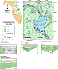
Lake
Harney straddles the Volusia-Seminole county line along
the St. Johns River. The lake is part of the St. Johns
Wet Prairie of the Eastern
Flatwoods District (Brooks
and Merrit, 1981). The series of lakes along the St.
Johns River in this area occupy valleys previously incised
by Late Pleistocene fluvial-lagoonal processes. The area
is low-lying and predominantly marshland. Lake elevation
at the time of the seismic survey was ~1.8 m (6 ft) NGVD.
Gopher Swamp appends to the east, separated from the lake
by Stone Island. Black Cypress Swamp is connected to the
lake via Underhill Slough to the northeast. The St. Johns
River enters Lake Harney from the south and flows out
to the north. Lake Harney is roughly oval in shape, with
20 km (12 mi) of shoreline and a surface area of about
24 km2.