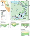
Lake
Jessup joins the St. Johns River system between Lakes
Harney and Monroe,
in Seminole county. The lake occupies the broad solution
valley of the St.
Johns Offset (Brooks,
1981). Lake elevation at the time of the seismic survey
was about 1.4 m (4.7 ft) NGVD. Lake Jessup is irregular
in shape, covering about 40 km2
with about 65 km (40 mi) of shoreline. The irregular shoreline
of Lake Jessup exemplifies the differences between lakes
which occupy dissolution and incised valleys with those
that are a single subsidence type lake such as Kingsley
Lake. Low-lying marshland of the solution valley surround
much of the lake to the north and east, with higher ground
approaching from the south.