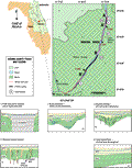
The
Wekiva River is a northward flowing (exotic) river defining
the Seminole/Orange/Lake county lines. The river occupies
the solution valley of the St.
Johns Offset (Index
Map E) within the Central Lakes District (Brooks
and Merrit, 1981; Merrit, 1981). Wekiva River drains
the lowlands of the Offset, but is sourced by the high
magnitude discharge springs located along the Apopka Upland
to the south. Rock Spring, Wekiva Spring and Spring Lake
source the Wekiva and Little Wekiva Rivers. The river
flows through the Wekiva Swamp, incises an unnamed highland
which supports a highway and the town of Wekiva and empties
into the St. Johns River at the Seminole-Volusia border
enhanced the broad valley through which the Wekiva, St.
Johns and Oklawaha Rivers flow. The flood plain is near
sea level, as well as the potentiometric surface of the
Floridan aquifer. The area is characterized by numerous
lakes which are at or slightly above the potentiometric
surface of the Floridan aquifer. Surficial drainage is
internal and water is stored in the surficial aquifer
within thick sands and gravels that comprise the near
surface in the area. During recharge and discharge conditions,
breaches through the underlying sandy clays of the Hawthorn
Group may provide a direct hydrologic connection with
the Floridan aquifer.