|
|
|
Lake
Jessup
|
|
|
|
Subsurface
Characterization
|
|
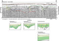
Seismic
profiles from Lake Jessup show a high occurrence of subsidence.
Areas of subsurface discontinuities predominate in two
areas of the lake, around Caldwells Field and Bird Island
(Index Map E). The
area around Bird Island shows subsidence extending deep
into the subsurface (A-A’
and B-B’), with
a discontinuous strong reflection at about 16 m (52.5
ft, red). Gamma logs indicate the top of the Ocala Limestone
to be at about 24 m (79 ft) below mean sea level, in close
approximation to this reflection. Collapse in the Ocala
results in subsequent subsidence in the shallower sediments,
shown by the green reflections in example profiles. These
sediments are the competent sands and clays of the Hawthorn
Group. Accommodation-related stress fractures and slumping
are also apparent around the areas of subsidence. Low-angle
to horizontal reflections within the depressions (B-B’),
along with a chaotic signal (A-A’),
indicate differing processes of fill; with modes of transport
ranging from fluvial to gravity (collapse) driven. The
subsurface structure may be responsible for the presence
and location of Bird Island. Profiles A-A’
and B-B’ show
a structural high in the lake bottom created by adjacent
areas of subsidence. This rise is translated to the surface
where island development could have become pinned to this
topographic high.
|
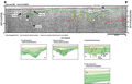
The
area around Caldwells Field shows similar subsidence in
the shallow subsurface, but collapse in the deeper reflection
is not as apparent (C-C’).
The Distribution of
Features map shows the area where surface subsidence
in this area occurs. The thickness of the overlying fill
appears to be greater and is comprised predominantly of
low-angle reflections. The fill appears to be more extensive
than the underlying subsidence and is perhaps associated
with the deeper areas of subsidence toward the central
part of the lake.
|
|
|
|