|
|
|
|
Index
maps that show the hydrography of the region and provide
background for navigation tracklines were generated from
standard USGS Digital Line Graph (DLG) datasets using
Qeoquest CPS-3 software products. The hillshade maps showing
topographical relief were generated from USGS gridded
datasets using ESRI ArcView 3.0. Seismic profiles were
scanned from analog copies. All page layout of figures
and text was accomplished with the drawing programs Deneba
Canvas, Adobe Illustrator and Adobe InDesign for Macintosh
computers. In addition, internet translation was accomplished
with Macromedia Dreamweaver and Macromedia Fireworks.
|
Reflective
horizons from a lake that were laterally continuous and
representative of a subsurface feature or the lake bottom
were digitized using a standard digitizing table that
have been eroded from the areas bordering the lakes have
been deposited in the lakes and migrated downward into
the space created by dissolution. The elevation of the
bottom of these depressions may represent the base level
of erosion as constrained by the potentiometric surface
of the Floridan aquifer.
|
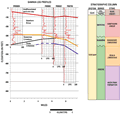
The
hillshade views (for example, Index
Map A) commencing the subsections were generated in
ArcInfo from a grid of topographic elevations interpolated
rom existing five foot contours depicted on USGS topographic
maps. Data is projected to UTM, Zone 17, NAD 1983, 1990
correction and copied to double precision. Location of
wells used for gamma log cross sections are included to
show the proximity of well data to the study sites.
|
|
Hillshade
views help emphasize the surface characteristics of the
physiographic provinces surrounding the sites profiled.
Lake distributions varies within high sand ridges to low-lying
flood plains of modern and ancient river systems. The hillshade
views also show how the topography greatly effects the surface
water drainage. Many of the lakes are concentrated within
the higher sand ridges and form depressions in the surface.
The concentrations of slightly acidic water within the lakes
provides a mechanism for enhanced dissolution of the underlying
carbonates and other sediments. Many lakes are closed basins
with no external drainage. In many cases, sediments eroded
from the lake margins have been deposited in the lakes and
migrated downward into the space created by dissolution.
the elevation of the bottom of these depressions may represent
the base level of erosion as constrained by the potentionmetric
surface of the Floridan aquifer.
|
|
|
|