|
|
|
Methods
|
|
Geophysical
Well Logs
|
|
Natural
gamma ray logs (for exampe, Index
Map A, A-A’)
were used for correlating geologic units to the seismic
reflection data. Logs used in this report are part of
the SJRWMD geophysical log data base and accessed through
GeoSys/4G software version 1.1 developed by Dr. Robert
Lindquist and Dr. Daniel Arrington of Gainesville, Florida.
Sources of the gamma logs include wells logged using SJRWMD
equipment and logs digitized from various agency files
or private consultant reports submitted to the SJRWMD.
|
Gamma
logs are scaled in counts per second (cps), which provide
a relative indication of gamma ray intensity. Relative
gamma ray intensity can be used to identify boundaries
between geologic units. The contact between the Miocene
Hawthorn Group sediments and the Eocene carbonates is
generally identified by low cps (Index
Map A, A-A’)(0
to 50) in the Eocene carbonates and higher cps (>50) in
the Miocene and younger sediments. Additionally, the Miocene
sediments are highly variable and units within the section
could vary from 20 to >1000 cps. Many factors influence
the absolute values that are recorded (borehole diameter,
size of the probe crystal) but a characteristic “signature”
can usually be identified. Pliocene and Pleistocene sediments
that overlie the Miocene sediments may be identified by
a reduction in cps. These sediments are generally sands
and sandy clays, commonly reworked Miocene sediments are
present and may greatly increase the cps.
|
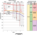
Cross
sections of the gamma logs available near the surveyed
lakes are provided to show the contacts of geologic units
that could be readily identified (Fig
4). Elevation of the geologic contacts were interpolated
to the sites that were profiled and converted to two-way
travel time and correlated to reflections that may represent
the contacts. Since the lakes generally represent areas
of increased stratigraphic disturbance, the elevation
of the contacts are highly variable. Reflections from
the least disturbed area within a site were used to correlate
to the gamma logs. In some cases, the contact could not
be identified but a strong reflection within a geologic
unit is identified to show subsurface structure.
|
|
|
|