|
|
|
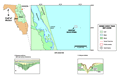
Crescent
Beach Spring
|
|
|
|
Subsurface
Characterization
|
|
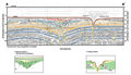
What
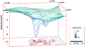
is readily apparent in the HRSP examples is the very large
(~1 km) subsidence feature evidenced by the downwarped
reflections within the Hawthorn Group. Discontinuities
in the horizontal reflections (yellow vertical lines)
may represent stress fracturing associated with the downwarping.
Meisburger and Field
(1976) identify this large subsidence feature as a
pronounced fold. Popenoe
and others (1984) identified the top of the Eocene
on the downward flexure of the fold to be between -47
m (-150 ft) in the undisturbed section to about -75 m
(-240 ft) at the deepest part. Karst-related dissolution
at depth and subsequent near-surface subsidence might
be another explanation, rather than a structural fold.
The area highlighted by a green background (A-A’
and B-B’)
appears to contain offlap and cross-bedded reflections
that may represent fill when the depression was exposed.
|
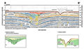
The
downwarped reflections of the Hawthorn Group are truncated
at about 22 m depth, shown by the blue dashed line in
the example profiles. This surface, and a second one near
surface (red dashed line), may represent erosional surfaces
related to sea level low stands. The area highlighted
by a red background shows a second depression with offlap-
and cross-bedded fill. This feature may represent an area
of resumed subsidence following the first sea level cycle.
It may also be an incised fluvial channel with fill occupying
the topographic low created by the original subsidence
event. These sequences of truncation surfaces and fill
may be remnants of the last two sea level cycles, the
parallel reflections overlying these sequences being the
most recent marine deposition.
|
|
|
|