|
|
|
Upper
Lake Louise
|
|
|
|
Subsurface
Characterization
|
|
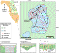
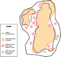
The
seismic data from Upper Lake Louise is generally obscured
by multiples in areas of bathymetric lows, as shown in
the Distribution of Features
map. This is consistent with lake bottoms of homogeneous
sands, but also may be due to organic material accumulating
in the deepest portions of the lake which tend to absorb
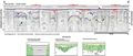
the acoustic signal. The southern portion of the lake
is characterized by a strong reflection at 20-24 ms (solid
blue line, middle of C-C’).
Depth to this mid-level horizon is shown in red numbers
on the Distribution of
Features map, and indicates a slight dip to the south
across the lake. Correlation with gamma logs from wells
adjacent to the lake would suggest that the horizon represents
stratigraphy within the Hawthorn Group. The horizon is
overlain by material of low reflective potential, possibly
fill material or massive clays (middle of C-C’).
Sediments within the Hawthorn Group exhibit major slumping
and discontinuities, as seen in the example profiles.
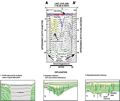
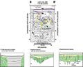
Profiles A-A’ and
B-B’ show possible
sinks, along with accommodation fractures or faults adjacent
to the subsidence. The northern portion of the lake is
characterized by numerous type 4 features (A-A’,
B-B’, C-C’),
or a common characteristic where dip in a reflection is
apparent but obscured by noise (C-C’).
The features extend from near the lake bottom to depth
and may indicate areas of potential leakage. A horizon
very near the sediment surface can be resolved from the
data (solid blue line), with infilling (red lines). At
depth, a strong reflective horizon is evident between
30-48 ms (dashed green line). The horizon is punctuated
by numerous discontinuities and elevation changes. The
gamma logs indicate the top of the Ocala Limestone to
be at about -15 to -24 m (-50 to -80 ft) below mean sea
level, which correlates with this horizon. Dissolution
of the Ocala Limestone would cause the subsidence seen
in the overlying material of the Hawthorn Group. If the
material above the mid-level horizon is impermeable massive
clays, the discontinuities represent major breaches across
the confining unit. Evidence of the breaches are substantiated
by reports from local residents who indicate that a spring
once flowed from the northwest section of the lake decades
ago (Track Map).
The spring was used as a water supply until flow ceased
as the majority of the region changed from an area of
discharge to recharge to the Floridan aquifer (Boniol
and others, 1993).
|
|
|
|