|
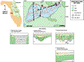
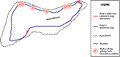
Lake Dias is located in north-central Volusia County. The lake
lies on the northern part of the Deland
Ridge, near the eastern edge of the Central Lakes District
which is the principle recharge area for the Floridan aquifer.
The ridge straddles the swampy lowlands of Lake Woodruff to the
west and Little Haw Creek to the east. The Crescent City-Deland
Ridge physiographic subdivision consists of sand hills with summits
generally between 24 and 30 m (79 and 98 ft) in elevation. Plio-Pleistocene
sand and shell rest directly upon the Floridan aquifer. The lake
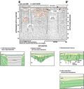
level at the time (August, 1994) of the seismic survey was 10.6
m (35 ft) NGVD. Lake Dias is oval in shape, with a perimeter of
8.7 km, an area of 4.3 km2, and average water depth
of approximately 3 m (6 ft).
|