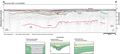
The
area surveyed near Drayton Island in Lake George occupies
southernmost Putnam County. The lake is part of the St.
John’s River system and the broad valley of the St.
John’s Offset. The development of this valley
is due in part to solution in the underlying limestone,
which nears the surface in this area. The lake is bound
on either side by the sand hills of the Crescent City
Ridge to the east and the Ocala Scrub physiographic region
to the west. The flood plain is characterized by swamp
vegetation. Four seismic lines, approximately 12 km (7.5
mi), were run around the island. Data quality is typically
poor due to noise and ringing in the acoustic return.
Possible reasons include accumulation of organics at the
river bottom, tightly packed sand in the near-surface
and echoes from the nearby shoreline obscuring the signal.