|
|
|
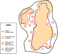
Upper
Lake Louise
|
|
|
|
Subsurface
Characterization
|
|
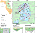
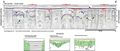
The
surficial material of the Crescent
City-Deland Ridge is composed of sand and shell. The
ridge overlies the Hawthorn Group or in places directly
overlies the Ocala Limestone (Brooks,
1981). Johnson
(1986) describes a very thin Hawthorn Group (<3 m
or 10 ft) at minus 1.5 m (5 ft) NGVD in a well about 5
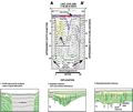
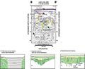
km (3 mi) northwest of the lake. Natural gamma logs from
wells depicted on the gamma log profile sheet (Index
Map D, wells P-0410,
P-0146, P-0011)
show logs with sufficient counts per second to characterize
the Hawthorn Group. In some areas during deposition Hawthorn
sediments have been reworked with the surficial Plio-Pleistocene
sands of the Crescent City-Deland Ridge. The gamma response
from these sediments may drop significantly as in well
V-0283 located
to the south. This situation makes delineating the Hawthorn
Group more difficult. The top of the Floridan Aquifer
was contoured by Rutledge
(1982). For this area he identified this surface between
-12 to -15 m (-40 to -50 ft) NGVD. The natural gamma log
profiles also show this contact at -15 m (-50 ft) NGVD
in wells P-0410
and P-0146, but
it is not identifiable in P-0011
and P-0495 from
the gamma logs alone.
|
|
|
|