|
|
|
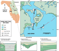
Drayton
Island
(Lake George)
|
|
|
|
Subsurface
Characterization
|
|
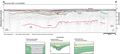
Profile
B-B’ exhibits
similar fluctuations to the karst surface, with another
incised channel taking shape (brown and orange lines)
before being obscured by noise in the record. The truncation
surface and subsequent depositional event represented
by the solid red lines in profile A-A’
are not as readily apparent. It is possible that the orange
lines in profile B-B’
may be correlative with this depositional event. The more
recent hiatus (dark blue line) and overlying fluvial deposits
are consistent in both profiles. The relationship of these
incised channels to subsidence in the underlying geology
is probably geomorphologic; channel development occurred
within previously existing depressions and was not necessarily
concurrent to karst development.
|
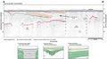
The
shape of the channel incisions and the nature of their
fill are similar to buried incised channels observed in
seismic profiles acquired from the nearshore shelf environments
of the Gulf and Atlantic coasts. The feature outlined
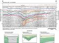
in profile C-C’
is characteristic of karst-type subsidence rather than
a fluvial incision. Again the deepest red reflection may
be correlative to the top of the Ocala Limestone, the
overlying reflections may represent subsequent subsidence
in the sediments of the Hawthorn Group. Reflections exhibit
subsidence up to the near-surface, suggesting the karst
feature in this profile post-dates the fluvial deposition
shown in the previous two profiles. The uppermost subsurface
reflections (dark blue line) is again overlain by high
frequency, parallel reflections which may be representative
of recent fluvial deposition.
|
|
|
|