|
|
|
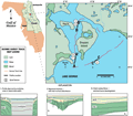
Drayton
Island
(Lake George)
|
|
|
|
Subsurface
Characterization
|
|
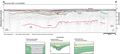
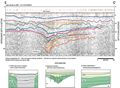
Three
example seismic profiles near Drayton Island show several
different types of geologic characterization present within
the St. Johns River Valley. Karst development in the underlying
limestone is accompanied by fluvial-type incised channels,
occupying areas of subsidence caused by the loss of material
at depth. Profile A-A’
shows relatively mature karst development in the limestone,
represented by the red dashed line at 30 to 45 m (92 to
148 ft). Gamma log profiles from four wells surrounding
the northern portion of Lake George (P-0410,
V-0346, M-0149
and M-0021; Index
Map D) show a highly fluctuating upper contact to
the Ocala Limestone. Depths to limestone range from greater
than -61 m (-200 ft) below sea level southwest of Drayton
Island, to -30 m (-100 ft) to the west, to -15 m (-50
ft) at the lake’s eastern shoreline. The variability
and range are consistent with the contact represented
by the red dashed line on profiles A-A’
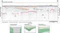
and B-B’. In
profile A-A’,
a fluvially-incised channel (light brown line) appears
to reside over one of the more pronounced depressions
in the karst surface. Multiple incisions appear within
the channel (orange line) with fill (purple lines). Channel
development was apparently terminated and a planing surface
(green line) is overlain by a more recent depositional
event (solid red lines). This sequence can be correlated
to spikes in the gamma counts at -12 m (-40 ft) below
sea level (P-0410,
V-0346 and M-0149),
suggesting a fluvial source, possibly a Pleistocene flooding
surface and estuarine deposition, as seen elsewhere within
the St. John’s Offset (Brooks
and Merrit, 1981). These low-angle reflections are
also truncated (dark blue line) and what appear to be
recent, riverine deposits occupy the nearsurface of the
profile. On the right side of the profile there appears
to be another drop in the limestone surface which is also
occupied by a channel incision (green lines), but most
of this feature is obscured by noise in the seismic record.
|
|
|
|