|
|
|
Karst
Development and Characterization
|
|
Types
of Sinkholes
|
|
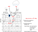
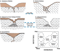
Karst
topography is the result of sinkholes: funnel, bowl or
cylindrical-shaped depressions that form to accommodate
loss of material due to dissolution in the underlying
carbonate rock. Dissolution creates a subsurface conduit
system that leads to collapse and sinkhole formation at
the surface (Arrington
and Linquist, 1987). In Florida, sinkhole type and
lake development depend primarily on three factors: 1)
proximity of the limestone rock to the surface; 2) thickness
of the overburden (confining unit); and 3) location of
the water table and potentiometric surface. Figure
11 shows a classification of sinkholes that has been
developed based on these factors. When the water table
is deep below the ground surface, dissolution of the rock
occurs within the unsaturated rock, creating a conduit
system that transports overlying material downward. If
overburden is present, it is removed through the conduit
system, causing subsidence at the surface (Fig.
11A). If no overburden is present, the self-accelerating
process of dissolution eventually removes all the material
at the surface and the conduit system develops progressively
downward (Fig.
11B). Where the ground is close to the surface, fluctuations
in the water table create a void system along the zone
of fluctuation. Downward dissolution above the water table
directly undermines the surface, eventually causing a
collapse. If overburden is present it will slump into
the hole, sometimes catastrophically (Fig.
11C). Lack of overburden will create a direct connection
between the surface and any underground void or cave system
(Fig. 11D).
A transitional type of sinkhole (Fig.
11E) straddles the end member classification in that
deposition of material in the depression created by dissolution
can occur during subsidence or collapse, or after dissolution
has ceased. In Florida this type of sinkhole can be found
very near the surface with recent infilling, or deep in
the subsurface from paleokarst development. Buried sinkholes
can also reactivate since they continue to be preferential
pathways for groundwater movement.
|
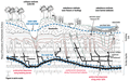
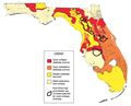
Figure
12 incorporates near surface
geology (factors 1 and 2 mentioned previously) with depth
to aquifer (factor 3) to map the distribution of sinkhole
types in Florida. When compared to the surficial geology
map (Fig. 5,
Regional Geology),
it is apparent that in areas where the competent overburden
of the Miocene sediments overlie limestone that is in
close proximity to the surface, there is the highest likelihood
of cover-collapse sinkholes (Lake and eastern Marion counties).
Areas of loose Quaternary fill typically experience the
slower developing cover-subsidence sinkholes that are
most commonly found along the eastern seaboard.
|
|
|
|