|
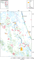
Surveys
of sinkholes were conducted in part to test the effectiveness
of shallow-water marine geophysical techniques in determining
the geomorphology of karst features. Investigation of subsurface
karst features has proven to be a difficult task. Due to their
random, unpredictable distribution, natural cavities or buried
sinkholes are notoriously difficult and expensive to locate and
assess in site studies. There are several direct and indirect
methods of
mapping and identifying features associated with karst, all of
which have limitations. Waltham
(1989) pro vides a review of the methods used for the
detection of cavities. Methods of geophysical applications used
in cave and sinkhole detection have been reviewed by Bates
(1973), McCann and others
(1982), Owen (1983),
and McCann and others (1987).
These authors, however, report that previously applied geophysical
techniques had little reliability for widespread use, but the
potential cost savings compared to other methods warrant consideration.
High-resolution seismic-reflection profiling (HRSP) been used
to detect subsurface features related to karst in lakes and rivers
with varying degrees (Missimer
and Gardner, 1976; Locker
and others, 1988; Snyder
and others, 1989; Sacks
and others, 1991; Subsurface
Detection Inc., 1992; Kindinger
and others, 1994, 1996, 1998, 1999) and also offshore in the
Atlantic Ocean (Meisburger
and Field, 1976; Popenoe
and others, 1984; Snyder and others, 1989).
|