|
|
|
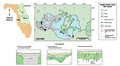
Lake
Kerr
|
|
|
|
Subsurface
Characterization
|
|
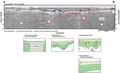
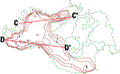
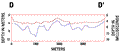
Lake
Kerr is characterized by numerous subsidence depressions
(type 2) tens to hundreds of meters in width (A-A’,
B-B’). Parallel
to low angle reflections within the depressions indicate
active infilling during subsidence. The low-angle reflections
appear to dip toward the southeast when present in the
record (black dip symbols, Index
Map D). This infilling gives the lake a smooth bathymetry
(brown line contour
map), unlike the highly irregular subsurface in which
the subsidence occurs (blue
line contour maps and 2-D profiles). The reflective
horizons that were digitized to produce the contour maps
are shown on the seismic examples. The north and south
cross sections, derived from the gridded contour data
sets, shows this contrast very well and may indicate that
subsidence had matured prior to deposition of the nearsurface
sediments.
|
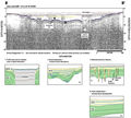
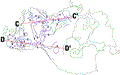
Noise
in the seismic record decreases in the eastern part of
the lake and deeper reflective horizons can be seen (A-A’,
red line). The acoustic signal in the lower horizons is
more chaotic and contains very high angle reflections,
whereas the upper horizons have lower angle, intact reflections.
It seems apparent in the seismic profiles that more solution-type
collapse has occurred in the lower horizons and that it
has influenced a more gradual subsidence in the overlying
material (blue line). During subsidence the depressions
were filled, possibly during migration of paleo-dunes
that define this physiographic region.
|
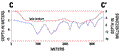
The
contact between the Ocala Limestone and the Hawthorn Group,
as interpreted from gamma log profiles, is deeper than
resolvable depth in the seismic profiles. However, changes
in gamma counts in a well northeast of the lake (well
M-0149, Index
Map D) within the Hawthorn Group may correlate with
the reflective horizons within profile A-A’
at about 12 m.
|
|
|
|