|
|
|
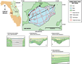
Lake
Disston
|
|
|
|
Subsurface
Characterization
|
|
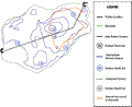
Lake
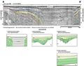
Disston is characterized by a variety of seismic reflections.
These reflections are consistent throughout the lake and
are represented by the colored lines in seismic profiles
A-A’ and
B-B’. The lines have been digitized and the depths
to the reflections plotted as contour maps shown at right.
In the eastern part of the lake there is a large subsidence
(> 1 km), obscured by noise in the record (A-A’
and Contour Maps 1,
2, 3).
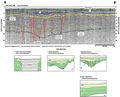
The western part has several smaller, near surface and
deeper depressions (types 2 and 3, B-B’).
The deep subsurface relationship between this complex
and the larger subsidence is uncertain. Seismic profile
B-B’ shows
a deeper subsidence (type 3) with infilling by Hawthorn
Group sediments that appear to have fracturing or dissolution
type features that have distorted the overburden (B-B’,
yellow line). These features may provide conduits for
surface water recharge of the aquifer. Except for near
surface sediments, the strata has subsided. High frequency,
horizontal reflections near the surface may represent
more lacustrine type fill, with no apparent disturbance
(right green line).
|
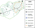
Logs
from wells in the area (Index
Map D, wells V-0339,
F-0296) show the
depth to the Ocala Limestone to decrease from about -46
m (-150 ft) NVGD east of the lake to about -15 m (-50
ft) NGVD to the west. The reflective horizon represented
by the dark green line in profiles A-A’
and B-B’, correlates
with this contact. The variable relief of this horizon,
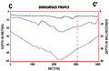
as expressed on the left side of profile A-A’,
and in the contour plot (Depth
to Limestone) and subsurface two dimensional profile
C-C’, is characteristic
of mature karst development and a subsidence sinkhole.
Besides the large depression in the east central portion
of the lake (Depth to Limestone), there also appears to
be dip in the karst surface to the northwestern portion
of the lake. The plot of the intermediate horizon shows
subsequent subsidence in the overlying Hawthorn Group
sediments.
|
|
|
|