|
|
|
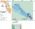
Davis
Lake
|
|
|
|
Geologic
Characterization
|
|
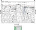
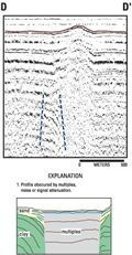
The
quality of the seismic profiles obtained from Davis Lake
is poor. Multiples of the bottom reflection are seen throughout
the data and obscure some of the record in the deeper
portions of the lake. The record is also partially obscured
in areas where the lake bottom nears the surface, as shown
midway in profile A-A’.
The multiples may be a result of lithologically homogeneous,
hard packed sands near surface which tend to set up ringing
in the acoustic return, accumulation of organic material
at the lake bottom may also attenuate the signal. Profile
A-A’ does show
one area of potential disturbance (red dashed line). The
high angle reflections, that become obscured by the multiples,
may represent a dissolution feature which would indicate
a breach in the overburden. The parabolic return (left-most
feature bracketed by red dashed lines) unfortunately is
also a pattern commonly associated with submerged pipelines.
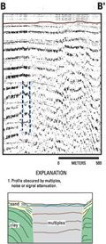
Three other lines that cross the same area are shown below
right (B, C,
D). The data is obscured
by multiples, but inconsistencies in the acoustic return
at depth may indicate a subsurface disturbance. Gamma-log
profiles in the area (wells V-0346
and P-0146) show
the contact between the Ocala Limestone and the overlying
Hawthorn Group rising from about 21 m (70 ft) below mean
sea level to the southwest, to 15 m (50 ft) below mean
sea level north of the lake. This corresponds to approximately
20 m (-65.6 ft) below lake bottom, using an averaged sound
velocity of 1500 m/s. This depth puts the top of the aquifer-bearing
Ocala Limestone very near the surface. A breach through
the overburden would increase the potential for contact
between the surface waters and the aquifer.
|
|
|
|