|
|
|
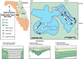
Cow
Pond Lake
|
|
|
|
Subsurface
Characterization
|
|
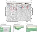
The
quality of the seismic profiles obtained from Cow Pond
Lake is generally poor. A strong bottom reflection leads
to multiples, seen throughout the data, that obscure some
of the record in the deeper portions of the lake. The
record is also partially obscured in areas where the lake
bottom nears the surface (B-B’,
C-C’). Areas
above the first multiple show sediment fill (type 6, C-C’)
and evidence of near surface subsidence (type 1, A-A’).
These patterns are identical by down-dipping reflections
on the flanks of a zone of obscured record. The type 1
features extend to depth in the profiles and occur in
numerous, constrained areas throughout the lake. Areal
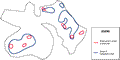
extent of features noted from the seismic profiles can
be seen in the map to the right. The Distribution
of Features map shows that the lake is comprised of
small solution/subsidence features rather than one predominant
subsidence as seen in other lakes. Most of the type 1
reflection patterns seen in the lake extend to depth from
the near lake bottom. Two areas of the lake, however,
show deeper solution/subsidence type features (red numbers,Track
Map) that do not extend entirely to the surface. These
features may have evolved on a different time scale (earlier
and infilled, or later and not fully developed) or hydrologic
regime than the other type 1 features. Throughout the
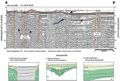
seismic profiles, segments of a strong reflection can
be seen at depth where the record is not obscured (blue
lines). These reflections may represent the karst surface
of the Ocala Limestone. Interpretations of gamma logs
from wells in the vicinity (Index
Map D, wells P-0416, V-0346,
V-0184) infer
the top of the Ocala Limestone to range from -15 to -22
m (-50 to -75 ft) below sea level. The depth corresponds
to 36 to 46 ms below the lake surface, using an averaged
sound velocity of 1500 m/s. This correlates with the strong
reflection seen in profile C-C’.
The material above the Ocala Limestone could be the sands
and clays of the Hawthorn Group and subsidence fill from
the Plio-Pleistocene ridge sediments.
|
|
|
|