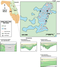
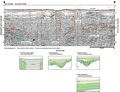
Seismic
profiles in Lake Como show many small (>100 m, 328 ft),
low angle reflections overlain and onlapped by horizontal
reflections (A-A’
and B-B’). These
features represent small-scale subsidence with subsequent
infilling. The areas of localized subsidence have been
mapped out in the figure showing areas of subsidence.
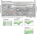
The subsidence features appear to be controlled at depth
by collapse in the underlying structure. This is shown
in profile B-B’
with downwarped reflections and subsidence-related faulting
(type 3). The near surface fill is nearly acoustically
transparent and is possibly homogeneous sands from the
surrounding sand ridges infilling the depressions. In
places the overburden appears to be displaced and rotated
as it slumps into the depression (north shore red number
2, Track Map). Gamma
counts from wells in the vicinity place the top of the
Hawthorn Group at about -9 m (-30 ft) NGVD and the top
of the Ocala Limestone at about -20 m (-65 ft) NGVD (wells
P-0114, P-0246,
Index Map D). The
reflection shown as a red dashed line in the seismic profiles
may represent a horizon near the top of the Hawthorn Group.
Subsidence in the Hawthorn Group sediments, as a result
of structural collapse in the underlying Ocala Limestone,
would provide recharge pathways to the aquifer. The near
surface undifferentiated fill appears to be relatively
intact, although some subsidence or breaches may be present
as shown in profile B-B’.