|
|
|
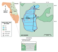
Lake
Wauberg
|
|
|
|
Subsurface
Characterization
|
|
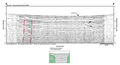
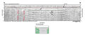
The
seismic reflection record acquired from Lake Wauberg is
predominantly obscured by strong multiples. In figure
A-A’ the multiples
appear to be originating from the lake bottom. It is also
possible that the multiples may be originating from a
hard surface very near the lake bottom as is apparent
in figure B-B’.
Typically, strong surface multiples are the result of
tightly packed sands or a hard surface near the lake bottom.
|
A
seismic refraction study, completed in the Lake Wauberg
area (Wiener, 1982),
resulted in a velocity analysis of the sediments and a
structural contour map of the top of the Ocala Limestone.
A depression in the Ocala surface was identified beneath
Lake Wauberg with a minimum elevation of -4.6 m (-15 ft)
NGVD. The elevation increased to 22.9 m (75 ft) NGVD below
the topographic ridges, with a maximum depth to the Ocala
beneath Lake Wauberg of about 82 ft. The elevation contours
are further supported by well data in the vicinity of
the lake.
|
Wiener
(1982) suggested that the Hawthorn
sediments were deposited into the existing depression
within the Ocala Limestone and was further thickened as
subsidence caused by dissolution of the underlying Ocala
Limestone occurred. Subsidence may affect the seismic
character of the sediments by disrupting bedding. The
seismic record from this site produced very few interpretable
features. This is unusual since at lakes where the formation
was caused by a central collapse or subsidence there is
usually sufficient detail around the perimeter to provide
some clues to the underlying structure. It appears that
the edges of the subsidence zone extend beyond the surface
expression of the lake and cannot be identified by marine
seismic methods.
|
|
|
|