|
|
|
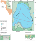
Lake
Lochloosa
|
|
|
|
Subsurface
Characterization
|
|
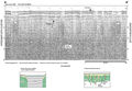
The
quality of the seismic profiles obtained from Lochloosa
Lake is generally poor. This is primarily due to both
a pervasive bottom multiple throughout the lake and abundant
acoustic noise in the subsurface. The latter is probably
due to the high organic content in the bottom sediments
seen in the marsh lakes of this area. Scott
(1988) describes the top of the Hawthorn Group (Coosawhatchie
Fm.) to be very near the surface in this area (<6 m, 19.7
ft). Although this is not readily apparent in the seismic
profiles acquired in Lochloosa, it does correlate with
some of the data obtained in neighboring Lake
Orange. In some areas of Lochloosa Lake, there does
appear to be a reflection visible at about 8 ms (6 m)
although it is not readily mappable due to the noise and
bottom multiple. The most characteristic feature visible
in the seismic profiles from Lochloosa are similar to
the type 1 feature shown in the explanation (A-A’).
This is a typical return in this type of lake and is probably
not related to subsurface structure. In several places
it is possible that numerous, high angle reflections may
indicate a type 4 feature (Track
Map).
|
|
|
|