|
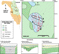
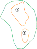
Indian
Lake is characterized by two areas of subsidence within
the lake. These areas are shown in the map to the lower
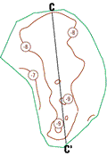
left. Seismic profiles A-A’
and B-B’ are
oblique cross-sections across the two depressions. Seismic
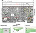
profile A-A’
shows a bi-directional view of the larger of the two subsidence
areas, as the survey trackline turns and crosses the depression
twice. The profile shows a strong reflective horizon (red)
about 28 m (92 ft) below lake level (9 m, 29.5 ft above
NGVD). This horizon is interpreted to be the top of the
Ocala Limestone, as correlated elsewhere in the study area
with gamma-log profiles. There appears to be an area of
collapse within the Ocala, approximately 150 m (492 ft)
wide, that has caused a concomitant subsidence in the overlying
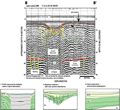
structure. Seismic profile B-B’
shows a smaller subsidence in the southern part of the lake.
Some structure such as collapse-related faulting is better
visualized in this record. Because of the lack of visible
features within the collapsed areas, these profiles show
characteristics similar to a type 1 interpretation as shown
in the explanation (left). In the uppermost part of the
profiles, a relatively transparent signal characteristic
of organic debris and sands (type 6) appear to be infilling
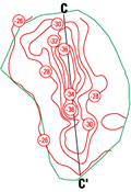
the depressions. Contour plots of the lake bottom and lower
horizon, digitized from the seismic profiles, are shown
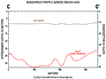
to the lower left. The cross section C-C’
was generated from the digitized surfaces.
|