The
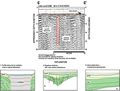
areas of subsidence seen within the lakes are well constrained
and do not have the appearance of large subsidence or
collapse sinkholes seen in other lakes. These localized
areas of subsidence may lie directly over centers of active
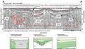
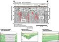
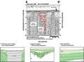
karst development. Lake Keene shows some larger solution
features at depth in the profiles (type 3, Track
Map). These features resemble the subsidence-type
features seen in other lakes and could represent a developing
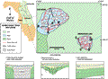
sinkhole. Profiles of gamma-log interpretations across
Lake Keene (Index Map
G, wells L-0677
and L-0679) show
the top of the Ocala Limestone dropping from +15 m (+50
ft) NGVD to -3 m (-10 ft) NGVD from north to south. Although
shallower, the transition between the consistent low angle
reflections in the seismic profiles and the underlying,
more jagged reflections (represented by dashed green lines,
A-A’ and
B-B’) may
represent this contact. Likewise, the transition may represent
a horizon near the contact between the top of the Hawthorn
Group and overlying undifferentiated fill. Dissolution
in the Ocala Limestone at depth could lead to subsequent
subsidence in the overlying sediments of the Hawthorn
Group and the undifferentiated fill, as outlined by the
red dashed lines in the seismic profiles.