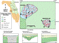
Lakes
Smokehouse and Keene are among a cluster of small lakes
in southeastern Lake County. The physiography is described
by Brooks and Merrit
(1981) as The
Gap, an area of lower elevation, about 25 to 37 m
(85 to 120 ft)between the Sugarloaf Mountain region and
No Name Ridge. The lower elevation is a result of increased
erosion of the underlying limestone. The Gap and the flanking
highlands are part of the Lake Wales Ridge, which is the
topographic crest of Central Florida (Brooks
and Merrit, 1981). The Ridge is characterized by residual
sand hills, relic beach ridges and paleo dune fields.
The topography on either side of the ridge has been reduced
to the water table, forming Green Swamp about 5 km (3
mi) to the southwest and Sawgrass Bays to the southeast.
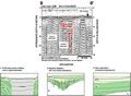
Lake levels for Lakes Keene and Smokehouse, 3 km (2 mi)
in December of 1995 were approximately 34 m (110 ft) and
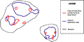
35 m (114 ft) NGVD, respectively. Lake Keene, the larger
of the two, is oblong, with a perimeter of 2.4 km (1.5
mi) and a surface area of about 0.2 km2.
Smokehouse Lake is roughly circular (roundness of 0.92)
with an area of 0.1 km2
and a perimeter of about 1 km (0.6 mi). The lake is connected
by surface drainage to other small lakes which drain into
Sawgrass Lake to the northeast.