|
|
|
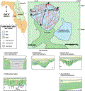
Lake
Dixie
|
|
|
|
Subsurface
Characterization
|
|
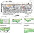
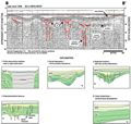
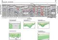
Seismic
profiles from Lake Dixie show a hard bottom reflection,
possibly from well sorted sands, infilling a deeper karst
surface (feature 6, A-A’).
The strong bottom reflection leads to multiples seen throughout
the data that obscure some of the record. Noise below
the topographic lows in the profiles also obscure some
of the record (green lines, B-B’).
This noise could be a result of the accumulation of organic
material in the depressions which attenuates the acoustic
signal. Despite the noise in the acoustic record, the
proximity of the underlying karst surface to the lake
bottom allows for a variety of solution and subsidence
type features to be seen. The subsurface is characterized
by numerous small depressions with high angle reflections
dipping toward their center (C-C’).
The high angle reflections may extend to depth in the
profile. These features may represent solution pipes dissolved
into the karst subsurface. Larger subsidence features
can also be seen in the profiles (type 3, A-A’).
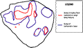
A plot of their distribution (blue line) shows three distinct
areas of subsidence and their influence on the lake’s
bathymetry (blue
line).
|
A
deeper, strong reflection can be seen in many of the subbottom
profiles (red line, A-A’,
B-B’). The highly
jagged appearance of this reflection is indicative of
an erosional (karst) surface seen in profiles throughout
the region. Interpretations of a gamma log acquired from
a well located approximately 1.5 km (.9 mi) southeast
of the lake (Index Map
G, well L-0677)
shows the top of the Ocala Limestone to be around 15 m
(50 ft) NGVD. This correlates well with the horizon seen
in the profiles. Differential dissolution in the Ocala
Limestone could lead to subsequent subsidence in the overlying
sediments of the Hawthorn Group and the undifferentiated
fill.
|
|
|
|