|
|
|
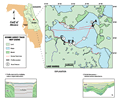
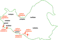
Lake
Harris
|
|
|
|
Subsurface
Characterization
|
|
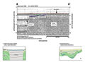
Multiples
persist in the seismic profiles throughout the central
portions of the lake. This is characteristic in lakes
where the bottom sediments are hard sands or rock. Not
enough data was collected to produce contours of subsurface
features, additional data is necessary to provide adequate
coverage. Scott (1988),
estimates the top of the Hawthorn Group to be greater
than 15 m (50 ft) above mean sea level in a nearby core.
Lake level at the time of the survey was 19 m (63 ft)
NGVD. This would suggest that the lakes that occupy the
interstices of the sand hills in this area are floored
within the Hawthorn Group, which contains phosphatic sands,
limestone and dolomites. In two places the acoustic return
is obscured by noise, or “gassed out” (C-C’).
This could indicate an accumulation of organic material
in the bottom sediments which acts to disperse the signal.
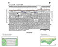
Profiles A-A’
and B-B’ show
areas where a reflective horizon can be seen dipping away
from the surface. Associated with this is a subsidence
depression in the lake bottom. The feature resembles that
of a type 2 feature, although little or no infilling is
visible in the record. Another possibility is that the
dipping horizon could represent a down-faulted or rotated
block that has subsided into a large collapse structure
at depth. However, multiples and noise obscure the record
so that if any deeper, influencing structures are present
they are not visible. Gamma logs indicate the top of the
Hawthorn Group to be near the surface from seven meters
depth to the west of the lake. The blue horizon from the
seismic profiles may correlate with this contact (A-A’,
B-B’ and Index
Map F). Profile C-C’
shows an example of small scale lake bottom subsidence
within the lake that could be considered an active sink.
No influencing features below the subsidence depression
can be seen because of the persistent multiples, although
dissolution within members of the Hawthorn Group is probably
occurring. The subsidences are similar in size to the
numerous small sinks visible to the south of the lake
and trending to the northwest. It is possible that the
lake bottom subsidences represent a lakeward extension
of this karst trend.
|
|
|
|