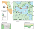
Lake
Harris is part of a chain of lakes that comprise the Central
Lakes region of the Central Lakes District. The county
name, Lake, further attests to the predominance of the
water-table lakes in this area. The district is characterized
as sand hill karst with solution basins (Brooks
and Merrit, 1981). In this area the Hawthorn Group
pinches out onto the Ocala Limestone. Lake Harris has
an irregular shape, covering 73 km2
with about 62 km (38 mi) of shoreline. The lake narrows
to Little Lake Harris to the south and Lake Denham to
the west. Dead River joins the lake with Lake Eustis to
the northeast. Sand hills with numerous small lakes within
their interstices trend southeastward from the southern
shore.