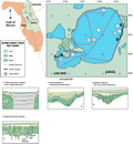
Lake
Weir, in southcentral Marion county, is situated along
the edge of the Ocala
Uplift in the Central Lakes District. This area is
comprised of sand hills with water table lakes filling
their interstices (Brooks
and Merritt, 1981). These sand hills comprise part
of the thick, undifferentiated sediments that overlie
the Hawthorn Group, which occurs at about sea level in
this area (Scott, 1988).
The lake wraps around the southern extent of one of these
hills to form Little Lake Weir to the west. Lake elevation
at the time of the seismic survey was ~16.7 m (55 ft)
NGVD. Lake Weir is roughly circular in shape with a perimeter
of approximately 35 km and an area of 31km2.
To the north, the lake is connected via drainage canal
to Marshall Swamp which occupies the large Oklawaha valley
and river system.